

Hiking in Crete: Explore Best Trails, Gorges, and Coastal Walks
Hiking in Crete is a wonderful way to experience the island's natural beauty. You're sure to find something to suit you, from leisurely strolls to challenging mountain hikes. Here's a small selection of hiking trails in Crete.
Best Hiking Trails in Crete
Samaria Gorge: Solo Hike or not in the National Park
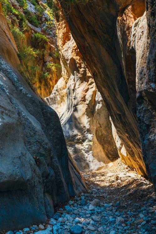
One of the most famous hikes in Crete is the Samaria Gorge. It's located in Samaria National Park in southwestern Crete.
Here you'll see steep walls and narrow paths. Simply breathtaking natural beauty!

Samaria Gorge: Hike and Route
Samaria Gorge is very long and runs from Omalos to Agia Roumeli.
The trail is approximately 16 kilometers (10 miles) long.
You should allow 4-6 hours for the hike.
The hike is of moderate to difficulty.
It does'n return to the starting point. You will reach the village at the end. From there, you will need to take a boat back.
Plan this hike carefully in advance.
Samaria Gorge: Viewpoints
You have breathtaking views of the steep rock faces and the plants of the gorge. There isn't just one viewpoint. The entire hike is like something out of a fairy tale.
Nature and Landscape
Samaria Gorge is known for its unique flora and fauna.
Which plants grow in Samaria Gorge?
Cretan cedar (Cedrus brevifolia): This tree species is endemic to Crete.
Cretan pine (Pinus brutia): A common tree species in the region, well adapted to the arid conditions.
Herbs and shrubs: These include various types of thyme, oregano, and other aromatic plants.
Wildlife:
Cretan wild goat (Kri-Kri): This endemic goat species is native to the gorge.
Birds: The gorge is a habitat for many bird species, including the griffon vulture and the golden eagle.
Reptiles: Various lizard species also live in the gorge.
The Samaria Gorge is an important nature reserve and a popular destination for hikers and nature lovers.

Weather Conditions and Hiking Time
Best time for your hike is from May to October. The gorge is closed in winter.
Equipment and Preparation
Good hiking boots, sufficient water, and snacks are essential. Be sure to wear sturdy shoes, as the trail is rocky! Hiking poles can help with the continuous downhill sections.
Samaria Gorge: Safety Information
Pay attention to weather conditions and check for possible trail closures. Remember that the gorge is closed during heavy rain in autumn.
Samaria Gorge: Accommodation and Services
Agia Roumeli offers accommodation and restaurants. Book in advance if you plan to stay overnight.
Samaria Gorge: Getting There and How Long It Takes
Omalos is approximately 170 km (105 miles) from Pitsidia.
From Pitsidia, drive to Timbaki. Then, via Agia Galini and Spili, head towards Rethymnon. Continue towards Chania. Finally, follow the signs to Omalos to reach the entrance of the gorge. Parking is available there. The entrance to the gorge is signposted.
The drive takes at least 4 hours.
E4 Hiking Trail: Crossing the Island from End to End
The European long-distance hiking trail E4 runs through the entire island of Crete. Some sections are challenging, while others are suitable for beginners.
Bring a good hiking map.
Prepare well so you stay on the right path.

E4: Hiking and Route
Length of the Trail: The entire trail is approximately 500 kilometers long.
Difficulty: The trail offers a range of difficulty levels, from easy to moderate to challenging, depending on the section. Both experienced hikers and beginners will find something to enjoy.
Some highlights of the hike:
Northern Coast of Crete: The trail begins near Kastelli and passes through picturesque towns such as Chania and Rethymno.
Samaria Gorge: A significant section of the E4 trail leads through the famous Samaria Gorge, a highlight for hikers.
Southwestern Coast: After the gorge, the trail continues to Agia Roumeli, following the coastline.
Loutro: The E4 leads to the village of Loutro, accessible only on foot or by boat.
Preveli: The trail continues towards the Preveli Monastery, offering magnificent views of the Cretan coast.
End Point: The E4 trail finally ends at Kato Zakros. The coastal scenery is impressive. You can also explore the ruins of the Minoan city.
Easier sections of the E4 hiking trail include:
The coastal section from Agia Roumeli to Loutro: This section runs along the coast. The path is relatively flat and easy to walk.
The section from Chania to Kalathas: This section leads through beautiful scenery and is not very steep. A pleasant hike with views of the coast.
The section from Rethymno to Plakias: This part of the trail runs through a mix of coastal landscape and rolling hills. The hike is pleasant and offers plenty of opportunities for breaks.
The section from Preveli to Agios Pavlos: This section is relatively easy. You'll have great views of the Libyan Sea.
The section from Kato Zakros to Xerokambos: This part of the trail is not very demanding. Enjoy the views of the coast and the mountains.
E4: Viewpoints
Some of the most beautiful viewpoints along the E4 hiking trail:
Samaria Gorge: The view of the steep cliffs and the impressive landscape is spectacular. The section at the end of the gorge, where it opens up, offers a particularly magnificent panorama.
Agia Roumeli: The Libyan Sea lies at your feet! Take a break and enjoy the view.
Loutro: This picturesque coastal village is surrounded by mountains. You'll have a view of the sea and the surrounding landscape.
Kefalonia Mountain: The trail leads to the highest point of the E4. Enjoy the views of the mountains and valleys.
Plakias: From the hills above the village, you have a fantastic view of the beaches and the sea.
Preveli Monastery: The view from the monastery of the coast and the palm groves is breathtaking.

E4: Nature and Landscape
The beauty of this route lies in the landscapes. Mountains, coasts, hills, always in alternation.
E4: Weather Conditions
The ideal time for the E4 hiking trail is from spring to autumn.
E4: Equipment and Preparation
A map of the E4 trail, water, and food are essential.
E4: Safety Information
Familiarize yourself with the details of each stage. Plan breaks and accommodations well in advance.
E4: Accommodation and Services
There are numerous accommodations and taverns along the trail.
Imbros Gorge
For a shorter hike, try the Imbros Gorge.
It's less challenging than the Samaria Gorge. The trail through the Imbros Gorge is also suitable for beginners. And you'll see impressive landscapes and views.
To get back to your car, you can either hike back up the gorge, take a taxi, or use the public bus.

Imbros: Hike and Route
The hiking trail begins in the village of Imbros and ends in Komitades.
Length: The Imbros Gorge is approximately 8 kilometers long.
Hike duration: approximately 2-4 hours.
Difficulty: The trail is rated as moderate. There are some rocky sections, but overall it is easily walkable.
Imbros: Viewpoints
There are many viewpoints along the way. You can admire the towering cliffs and the steep walls of the gorge!
At the end of the gorge, you'll have a beautiful view of the surrounding mountains and the village of Komitades.
Imbros: Nature and Landscape
In the gorge, you'll see pine trees, cypress trees, and various wildflowers.
Keep an eye out for native birds and other animals that live here. With a bit of luck, you might spot birds like:
Cretan Hoopoe (Upupa epops): This bird with its striking crest is a common sight.
Cretan Golden Eagle (Aquila chrysaetos): These majestic birds are often seen soaring high in the sky.
Common Swift (Apus apus): These swift birds are known for their acrobatic flight skills. They are frequently seen during the summer months.
Black Woodpecker (Dryocopus martius): This large, showy woodpecker lives in the region's forests. It's more often heard than seen. Listen for its distinctive drumming.
Chicken Warbler (Phylloscopus collybita): A small, unassuming bird. It lives in the bushes and trees of the gorge.
Crossbill (Loxia curvirostra): These birds crack open pine seeds. They use their special beaks, which cross over each other at the front, to do this.
Blue Tit (Cyanistes caeruleus): These small, colorful birds are common in the forests and gardens of Crete.
European Robin (Erithacus rubecula): A popular bird, often seen near hiking trails.

Weather conditions
The best time for a hike through the Imbros Gorge is in spring (April to June) and autumn (September to October). Temperatures are mild and not too hot then.
Equipment and Preparation
Footwear: Wear sturdy, comfortable shoes. Ideally, wear hiking boots with good tread.
Water: Please bring plenty of water. There are no springs along the trail.
Sun Protection: Sunscreen, sunglasses, and a hat are essential, especially during the summer months.
Hiking poles are a useful addition to your gear, depending on your preference.
Safety Information
Marking: The trail is well-marked, but pay attention to the signs to ensure you stay on the correct path.
Emergency Number: Familiarize yourself with the local emergency number in case of an emergency. In an emergency, call the European emergency number 112. This will allow you to be located immediately, provided your mobile phone is working.
Accommodation and Services
There are several accommodation options near the Imbros Gorge in the villages of Imbros and Komitades. Advance booking is recommended, especially during peak season.
Restaurants and Cafés: You'll find small tavernas in the villages where you can enjoy a meal after your hike.
Getting there and driving time
The distance from Pitsidia is approximately 120 km via the mountain route.
From Pitsidia, drive to Timbaki. Then continue via Agia Galini and Spili to Rethymnon. From there, head towards Chania. A few kilometers past Georgioupoli, take the exit towards Imbros Gorge and follow the signs to the gorge entrance. Parking is available there.
Driving time: approximately 2 hours.
Loutro – Chora Sfakion
Enjoy a scenic coastal walk with amazing views of the Libyan Sea and steep cliffs. This trail is of moderate difficulty and takes you past traditional Cretan villages.
Distance from Pitsidia: approx. 45 km.
Directions: Drive to Chora Sfakion and then take a boat to Loutro, or hike along the coastal path.
Agios Nikolaos – Kritsa
This walk in eastern Crete takes you through lovely villages and countryside, with beautiful sea and mountain views. It’s a moderate hike and less crowded than popular routes.
Distance from Pitsidia: approx. 45 km.
Directions: Head north to Agios Nikolaos, then follow signs to Kritsa.
Kourtaliotiko Gorge
This hike takes you through an impressive gorge filled with steep rocks and lush vegetation. It’s a great path for nature lovers and photographers.
Distance from Pitsidia: approx. 38 km.
Directions: Drive to Spili, then head south towards Kourtaliotis. Follow signs to the gorge parking area.
Agia Irini Gorge
This is a 7-kilometer hike through a green and calm gorge. It’s a little less challenging than the Samaria Gorge but still offers a beautiful nature experience.
Distance from Pitsidia: approx. 55 km.
Directions: Drive north towards the town of Margarites, then follow signs to Eleutherna. You can park in the village and start the hike from there.
Margarites Village to Ancient Eleutherna
This hike connects the traditional village of Margarites with the ancient ruins of Eleutherna. It goes through olive groves and hilly landscapes, providing stunning views along the way.
Distance from Pitsidia: approx. 23 km.
Directions: Drive north towards the town of Margarites, then follow signs to Eleutherna. You can park in the village and start the hike from there.
Many hiking trails pass through beautiful villages and olive groves, showcasing the island’s farming traditions.
Conclusion
Crete offers a wide variety of hiking trails for every skill level. Whether you’re exploring famous gorges, hiking along the blue coast, or discovering the island’s mountains, there’s something for everyone. With its mix of nature, history, and culture, Crete is a fantastic place for hiking lovers!